
Published 31 October 2026 · Launch date: 30 October 2026 · Source-led mission explainer
ISRO has confirmed that GSLV-F18 placed the NVS-03 navigation satellite into its intended orbit. The official launch register dates the mission to 30 October 2026, and the mission page identifies that orbit as a Geosynchronous Transfer Orbit, or GTO. The launch took place from the Second Launch Pad at Satish Dhawan Space Centre, SHAR, Sriharikota.
The important distinction is between the launcher and its passenger. GSLV-F18 is the rocket flight; NVS-03 is the spacecraft intended to support India’s NavIC navigation system. A successful launch is an important result, but it should not be confused with a separate confirmation that every later spacecraft and service milestone has been completed.
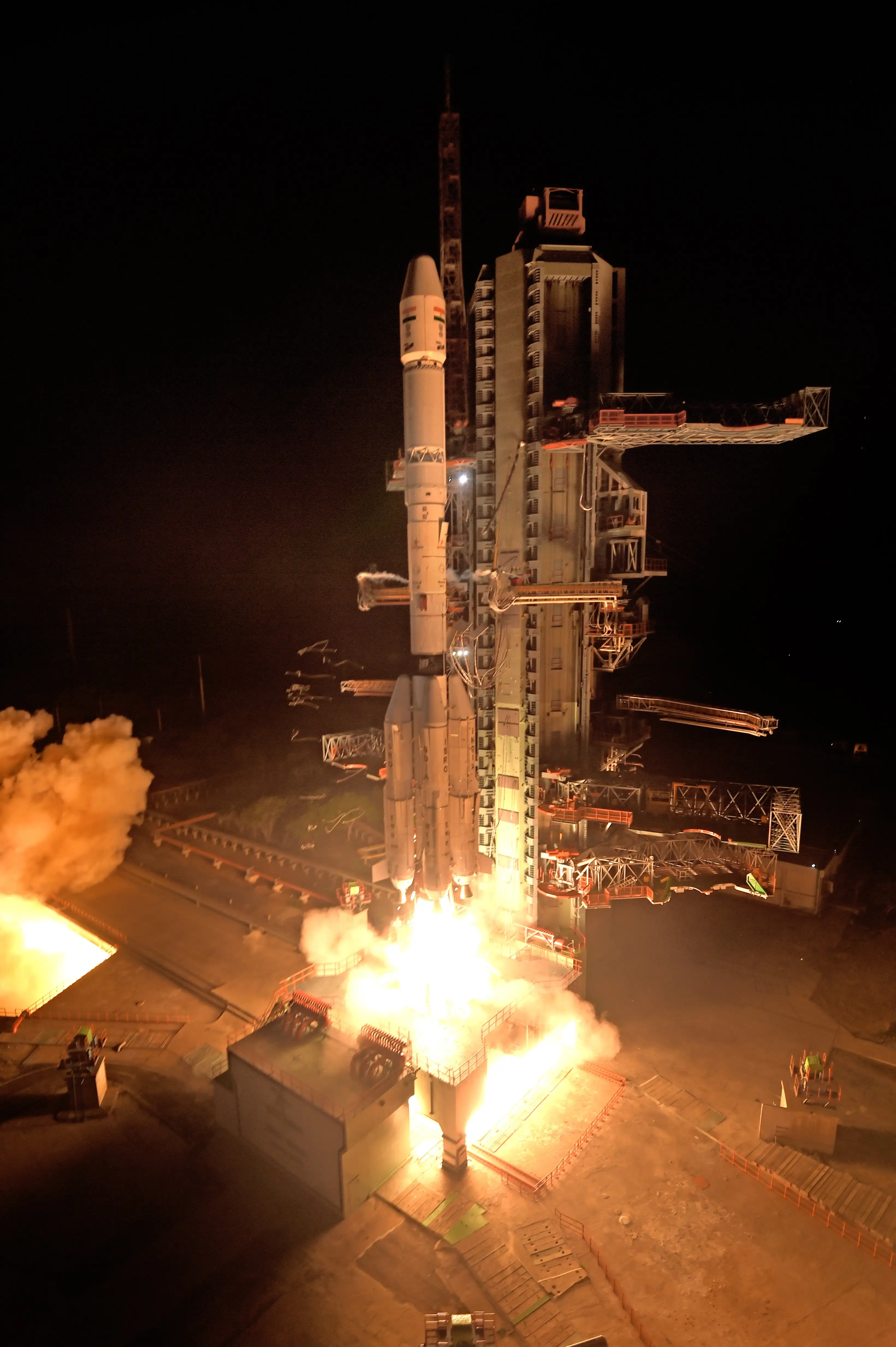
Image source: DOS/ISRO, GSLV-F18/NVS-03 official gallery. The lead photograph shows lift-off. Reproduced under ISRO’s copyright policy; no edits by Enlighten Chakra.
See the mission in pictures


Sources and image credits
GSLV-F18 lifts off: DOS/ISRO, GSLV-F18/NVS-03 official gallery. Reproduced under ISRO’s copyright policy. No edits by Enlighten Chakra.
The vehicle clears the tower: DOS/ISRO, GSLV-F18/NVS-03 official gallery. Reproduced under ISRO’s copyright policy. No edits by Enlighten Chakra.
NVS-03 spacecraft: DOS/ISRO, GSLV-F18/NVS-03 official gallery. Reproduced under ISRO’s copyright policy. No edits by Enlighten Chakra.
Watch the launch—and read the milestones
Watch ISRO’s official lift-off footage. For broadcasts, visit ISRO’s official YouTube channel. The channel link is not a verified mission-specific YouTube replay.
The first photographs show ignition, lift-off and the vehicle moving clear of its launch structure. They make the scale of the rocket easier to understand, but a photograph cannot establish the final orbit or the health of a navigation payload. For those claims, use ISRO’s mission report. Its confirmation of injection into the intended geosynchronous transfer orbit is the key launch result.
In a full mission broadcast, distinguish the ground camera from the flight information display. The camera shows the visible ascent; the display and spoken announcements identify mission events. Do not infer an exact separation time or altitude from the short lift-off clip. GSLV’s solid core, liquid propulsion and cryogenic upper stage perform different jobs over the flight, and the upper stage’s work continues after the vehicle has left the ground camera’s view.
For NVS-03, reaching a transfer orbit is a starting point for the spacecraft’s own work. Orbit raising, deployment, payload checks and entry into navigation service are separate milestones. An operational service announcement would therefore add information that the launch success report alone does not supply. The accompanying NavIC guide explains why a new satellite also does not automatically add compatibility to an existing phone.
The mission at a glance
| Item | What the official material says |
|---|---|
| Launch vehicle | GSLV-F18; the twentieth GSLV flight |
| Payload | NVS-03, the third satellite in the next-generation NavIC series |
| Launch date and site | 30 October 2026; Second Launch Pad, SDSC SHAR |
| Confirmed launch result | Placement into the intended Geosynchronous Transfer Orbit |
| Spacecraft features highlighted by ISRO | An indigenous atomic clock alongside procured clocks; L1 signals in addition to L5 and S |
| Mission brochure’s vehicle figures | Approximately 50 metres tall, approximately 420 tonnes at liftoff, three stages |
The dimensions are the mission-specific figures in the GSLV-F18/NVS-03 brochure. Its injection-orbit values are planning specifications: a 170 km perigee, a 37,023 km apogee and 20.75° inclination. They should not be presented as a separately published post-flight measurement of the achieved orbit. The brochure’s approximate payload figure is likewise not an independently measured launch-day mass.
What the three-stage rocket does
ISRO’s GSLV Mark II description explains a vehicle combining a solid first-stage core with four liquid strap-on boosters, a liquid second stage and a cryogenic upper stage. Different propulsion systems contribute at different phases of the ascent. The mission brochure identifies the F18 configuration as S139 with four L40H strap-ons, GL40HT and CUS15, under a 3.4-metre payload fairing.
The cryogenic stage uses liquid hydrogen and liquid oxygen. “Cryogenic” describes the very low temperatures needed to handle these propellants. In this mission’s story, the practical point is the upper stage’s role in delivering the spacecraft to its transfer orbit, rather than simply getting it above the atmosphere.
Why the transfer orbit is not the end of the journey
Perigee is an orbit’s closest point to Earth; apogee is its farthest. A transfer orbit is an intermediate trajectory, not automatically the spacecraft’s final operational arrangement. ISRO’s GSLV explanation describes the spacecraft using its own propulsion after injection to reshape its orbit.
Read the mission’s progress as a sequence: launch and separation, subsequent spacecraft operations, checks of the payload, and confirmation of service use. An announcement about the first milestone does not by itself establish the others. This article reports the confirmed injection result and does not infer a commissioning date from it.
What NVS-03 adds to the NavIC story
NavIC is India’s regional positioning, navigation and timing system. The mission page places NVS-03 in the next-generation series intended to maintain continuity with the earlier IRNSS satellites. It highlights both an indigenous atomic clock and additional L1 signalling. These are two different contributions: a timing reference onboard the spacecraft and a signal that compatible user equipment can receive.
ISRO’s navigation-services overview describes coverage over India and roughly 1,500 km beyond its boundary. NavIC is a regional system; this launch does not turn it into a global coverage network. Nor does one new satellite make every existing phone compatible with its signals.
Why clocks matter to a navigation satellite
Satellite navigation estimates range using radio-signal timing. As the FAA’s explanation of satellite navigation sets out, the receiver uses the difference between transmission and reception times along with satellite-position information. Multiple measurements allow it to solve for position and its own clock error. This explains why a stable timing reference in space is central to the task.
For scale, a one-microsecond timing difference corresponds to about 300 metres of radio travel distance in free space. That is an illustrative calculation, not a prediction of NavIC positioning error: a complete navigation solution includes clock corrections, propagation effects and other measurements. It shows why “a better clock” is an engineering topic with a practical connection to positioning.
L1, L5 and S are signals, not three new services
The band names refer to radio-frequency ranges. ISRO says NVS-03 adds L1 to the existing L5/S offering. The useful consumer question is whether a particular receiver supports the relevant NavIC signals, not whether a mapping app has changed its icon. Satellite capability, receiver capability and an application’s location display are separate parts of the chain.
For readers following the launch, the next useful updates are official statements about spacecraft orbit operations, payload checks and entry into service. Treat claims about instant improvements on every handset, complete replacement of GPS or a fully operational constellation as separate claims that need their own evidence.
Read the launch with the right questions
Ask three things when you see a mission headline: what did the launcher deliver, what is the spacecraft designed to do, and which later milestones have actually been confirmed? Those questions make it easier to distinguish an accomplished launch from a capability that still depends on the rest of the system.
Related explainer: Will NVS-03 improve your phone’s navigation? Signals, receivers and maps explained
ISRO mission update · Launch register · Mission brochure (PDF) · GSLV technical overview · NavIC services · Satellite-navigation timing background. Sources checked 31 October 2026. The mission page carries a 28 October page date; the launch register supplies the 30 October launch date. Planned brochure figures and confirmed launch results are distinguished above.
Leave a Reply